Battle of Thermopylae (480 BC)
Strategic and Tactical Considerations
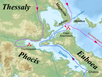
From a strategic point of view, by defending Thermopylae, the Greeks were making the best possible use of their forces. As long as they could prevent further a Persian advance into Greece, they had no need to seek a decisive battle and could, thus, remain on the defensive. Moreover, by defending two constricted passages (Thermopylae and Artemisium), the Greeks' inferior numbers became less of a factor. Conversely, for the Persians the problem of supplying such a large army meant they could not remain in the same place for very long. The Persians, therefore, had to retreat or advance, and advancing required forcing the pass of Thermopylae.
Tactically, the pass at Thermopylae was ideally suited to the Greek style of warfare. A hoplite phalanx could block the narrow pass with ease, with no risk of being outflanked by cavalry. Moreover, in the pass, the phalanx would have been very difficult to assault for the more lightly armed Persian infantry. The major weak point for the Greeks was the mountain track which led across the highland parallel to Thermopylae, that could allow their position to be outflanked. Although probably unsuitable for cavalry, this path could easily be traversed by the Persian infantry (many of whom were versed in mountain warfare). Leonidas was made aware of this path by local people from Trachis, and he positioned a detachment of Phocian troops there in order to block this route.

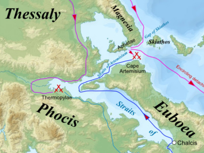
Map of Thermopylae area with modern shoreline and reconstructed shoreline of 480 BC

Map of Thermopylae area with modern shoreline and reconstructed shoreline of 480 BC
( Click image to enlarge)
Topography of the battlefield
It is often claimed that at the time, the pass of Thermopylae consisted of a track along the shore of the Malian Gulf so narrow that only one chariot could pass through at a time. In fact, as noted below, the pass was 100 metres wide, probably wider than the Greeks could have held against the Persian hordes. Herodotus reports that the Phocians had improved the defenses of the pass by channelling the stream from the hot springs to create a marsh, and it was a causeway across this marsh which was only wide enough for a single chariot to traverse. In a later passage, describing a Gaulish attempt to force the pass, Herodotus describes how the Gauls who fell into the marsh disappeared and were drowned.
It is also said that on the southern side of the track stood cliffs that overlooked the pass. However, a glance at any photograph of the pass shows there are no cliffs, only steep slopes covered in thorny bushes and trees. Although no obstacle to individuals, such terrain would not be passable by an army and its baggage train.
On the north side of the roadway was the Malian Gulf, into which the land shelved gently. When the Gauls attempted to force the pass, the shallowness of the water gave the Greek fleet great difficulty getting close enough to the fighting to bombard the Gauls with ship-borne missile weapons.
Along the path itself was a series of three constrictions, or "gates" (pylai), and at the center gate a short wall that had been erected by the Phocians, in the previous century, to aid in their defense against Thessalian invasions. The name "Hot Gates" comes from the hot springs that were located there.
The terrain of the battlefield was nothing that Xerxes and his forces were accustomed to. Although coming from a mountainous country, the Persians were not prepared for the real nature of the country they had invaded. The pure ruggedness of this area is caused by torrential downpours for four months of the year, combined with an intense summer season of scorching heat that cracks the ground. Vegetation is scarce and consists of low, thorny shrubs. The hillsides along the pass are covered in thick brush, with some plants reaching 10 feet (3.0 m) high. With the sea on one side and steep, impassable hills on the other, King Leonidas and his men chose the perfect topographical position to battle the Persian invaders.
HISTORY
RESOURCES
This article uses material from the Wikipedia article "Battle of Thermopylae", which is released under the Creative Commons Attribution-Share-Alike License 3.0.
© Stories Preschool. All Rights Reserved.
